Pella
Brief Overview
The city was founded in 399 BC by King Archelaus (413-399 BC) as the capital of his kingdom, replacing the older palace-city of Aigai. After this, it was the seat of the king Philip II and of Alexander, his son.
In 168 BC, it was sacked by the Romans, and its treasury transported to Rome.
Later, the city was destroyed by an earthquake and eventually was rebuilt over its ruins. By 180 AD, Lucian could describe it in passing as "now insignificant, with very few inhabitants".
Pella is first mentioned by Herodotus of Halicarnassus (VII, 123) in relation to Xerxes' campaign and by Thucydides (II, 99,4 and 100,4) in relation to Macedonian expansion and the war against Sitalces, the king of the Thracians.
According to Xenophon, in the beginning of the 4th century BC, it was the largest Macedonian city.
It was probably built as the capital of the kingdom by Archelaus, although there appears to be some possibility that it may have been Amyntas. It attracted Greek artists such the painter Zeuxis, the poet Timotheus of Miletus and the tragic author Euripides who finished his days there writing and producing Archelaus.
Archelaus invited the painter Zeuxis, the greatest painter of the time, to decorate it. He was later the host of the Athenian playwright Euripides in his retirement. Euripides Bacchae premiered here, about 408 BC.
Pella was the birthplace of Philip II and of Alexander, his son. The hilltop palace of Philip, where Aristotle tutored young Alexander, is being excavated.
In antiquity, Pella was a port connected to the Thermaic Gulf by a navigable inlet, but the harbor has silted, leaving the site landlocked.
The reign of Antigonus likely represented the height of the city, as this is the period which has left us the most archaeological remains.
In Detail
Pella is situated in the southeast of Bottiaia, the alluvial plain enclosed by the Axios and the Haliacmon rivers and bounded by the Bermion mountain range in the west an Mount Paikon in the north. In Antiquity, the northern shore of the Thermaic Gulf, larger than today, was close to the city.
The site was already known to Hecataeus in the late sixth century BCE, and is also mentioned by Herodotus, who tells that in the summer of 480, the fleet of the Achaemenid king Xerxes beached at Pella (Histories, 7.123). Shortly before 400, king Archelaus of Macedonia made it the capital of his kingdom, replacing Aegae as the main royal residence. Pella was soon known as "the greatest of the cities in Macedonia" (Xenophon, Hellenica, 5.2.13), and people like the tragedian Agathon and the painter Zeuxis were invited to come to and work in Pella. Euripides wrote his Bacchae here.
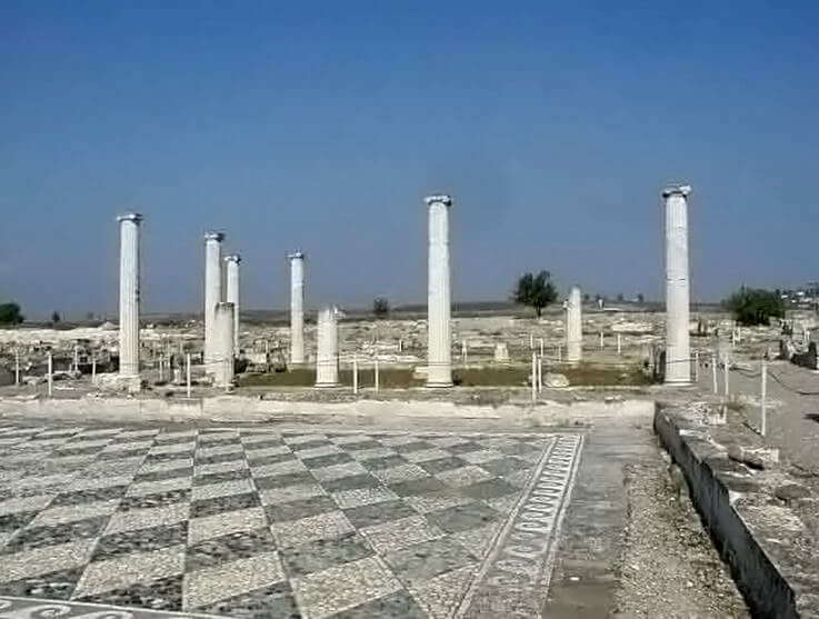
The city was built on a Hippodamean map with long building blocks, had an excellent sewer system, and was already fortified in the time of king Philip II (r. 360-336), who transformed Pella into a city of great international importance. Persian and Greek ambassadors met the king over here, while aristocrats built impressive houses with beautiful mosaics have been found, made of black and white pebbles. Archaeologists have also found some fine wallpaintings.
The royal palace, where Alexander the Great was born and educated, was on a hill in the northern part of the city. During the reign of Cassander (r. 319-298), the city was redesigned and occupied an area of about 2.500.000 square meters and was defended by a fortification wall with a circuit of around 8000 meters. The "House of the Abduction of Helen", which measures no less than 2350 square meters, was built in these years.
The city had institutions of its own, and had some liberty in its policy. Pella continued to flourish in the thirds century under Cassander's successors, the descendants of Antigonus II Gonatas (r. 283-239).
Having experienced its last decades of glory during the reigns of king Philip V (r. 221-179) and his son Perseus (r.179-168), Pella surrendered to the Roman general Aemilius Paulus, after his victory in the battle of Pydna in 168 BCE. Macedonia was divided into three republics, and Pella became capital of one of these. Later, when Macedonia was added to the Roman Empire, the Senate made Thessaloniki its capital, and even though the new Via Egnatia was designed to run through Pella, the city lost much of its splendor. An earthquake (or an invading Thracian tribe) in the first quarter of the first century BCE caused some destructions in the area of the agora, which were never repaired.
The settlement of veterans of the civil wars did nothing to prevent the demise of the city, which was, since the beginning of the reign of Augustus, known as Colonia Julia Augusta Pellarum. The city is shown on the Peutinger Map without any indication that it was very important.
Writing at the beginning of the second century, Dio of Prusa says that " if you should pass through Pella, you would see no sign of a city at all, apart from the presence of a mass of shattered pottery on the site (Oration 33, 27). Nevertheless, the city continued to mint bronze coins well into the third century. It was briefly renamed Diocletianopolis, but the old name came back into vogue. The site was still more or less inhabited in the seventh century, and there's a Byzantine source that claims that the tomb of Herodotus was in Pella.
Excavations
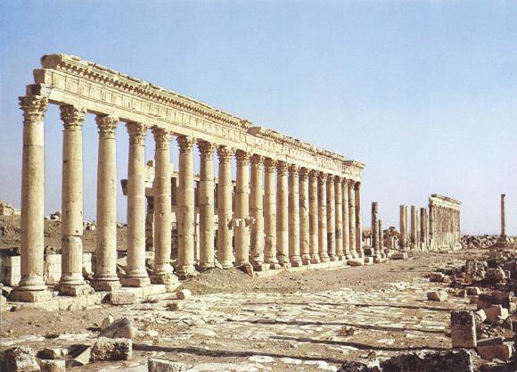
As indicated above, Pella is built on a Hippodamean plan, with long building block in a north-south direction. The agora covers two lines of five building blocks. With stoas encircling the square and shops on the sides, it formed a building complex of imposing scale.
Two types of house have been identified in the Macedonian capital: one with an interior peristyle and one with a pastas (a kind of portico). One of the wealthier houses with a peristyle is the famous House of Dionysus with is brilliant mosaic floors depicting Dionysus riding on a panther and a lion hunt. In the House of the Abduction of Helen, one can see, except for Theseus abducting Helen, a deer Hunt and an Amazonomachy.
The palace complex in the north has an area of 60,000 square meters. The central unit includes two open peristyle areas. Along the entire south side, the complex takes the form of a veranda (belvedere) of impressive size, from which the residents on high gazed upon the boundless plain and even the Thermaic Gulf. The central part of this complex was built at the end of the first half of the fourth century BCE, which suggests that Philip built it.
The earliest tombs have been found in the agora area. They were individual graves, cut into the soft limestone of the region, dating from the last quarter of the fifth to the third quarter of the fourth centuries. There are also cist graves and family vaulted rock-cut chamber tombs that survived the Roman conquest. The rich grave offerings like vases, jewellery, metal objects, and funerary furniture now adorn the display cases of the beautiful and modern museum on the site.
[1]
